| Bergen op Zoom | |
|---|---|
| — Vùng đô thị — | |
 | |
 | |
| Quốc gia | Hà Lan |
| Tỉnh | Noord-Brabant |
| Diện tích(2006) | |
| • Tổng cộng | 93,13 km2 (3,596 mi2) |
| • Đất liền | 80,76 km2 (3,118 mi2) |
| • Mặt nước | 12,38 km2 (478 mi2) |
| Dân số (1 tháng 1 năm 2007) | |
| • Tổng cộng | 65.454 |
| • Mật độ | 810/km2 (2,100/mi2) |
| Nguồn: CBS, Statline. | |
| Múi giờ | UTC+1 |
| • Mùa hè (DST) | CEST (UTC+2) |
| Mã điện thoại | 0164 |
| Thành phố kết nghĩa | Szczecinek, Oudenaarde, Edmonton |
Bergen op Zoom (ⓘ) là một khu vực đô thị và là một thành phố ở phía nam Hà Lan.
Khu vực dân cư

- Bergen op Zoom (dân số: 65.691, tháng 7 năm 2006)
- Heimolen
- Halsteren (11.410)
- Lepelstraat (2.070)
- Kladde
Địa điểm du lịch

- City Center (Centrum)
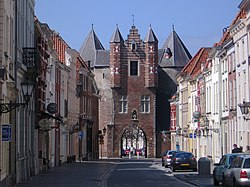
- Gevangenenpoort (hay Onze Lieve Vrouwepoort)
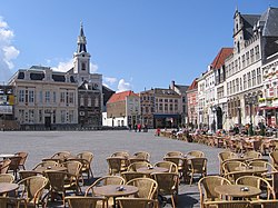
- Grote Markt
- Hotel & Residence de Draak
- Kaai (cảng cũ)
- Lievevrouwenstraat
- Markiezenhof
- Ravelijn (hay de Vest)
- Sint-Gertrudiskerk (hay Grote Kerk)
- Synagogue
- Di tích pháo đài Fort de Roovere và Cầu Moses với phần lớn chìm dưới mặt nước.
Đọc thêm
- A Ballad on the Taking of Bergen-Op Zoom. London: M. Cooper, 1747.
- Bot, Marie-Louise, and Gouke J. Bonsel. The Bergen Op Zoom-Quality of Life Survey: A Dutch Contribution to the Collaborative Study of the European Common Core Group. Rotterdam: Dept. of Public Health and Social Medicine/Institute for Medical Technology Assessment, Erasmus University Rotterdam, 1989. ISBN 9072245458
- Edler, Florence. Attendance at the Fairs of Bergen-Op-Zoom 1538-1544. Bergen op Zoom: [s.n.], 1936.
- Smyth, James Carmichael. Plans of the Attacks Upon Antwerp, Bergen-Op-Zoom, Cambray, Peronne, Maubeuge, Landrecy, Marienbourg, Philippeville and Rocroy, By the British and Prussian Armies in the Campaigns of 1814 and of 1815. 1817.
- 1939-1945 The War Dead of the Commonwealth: The Register of the Names of Those Who Fell and Are Buried in Cemeteries in the Netherlands: Bergen Op Zoom Canadian War Cemetery. Maidenhead: Commonwealth War Graves Commission, 1994.
Tham khảo
Liên kết ngoài
- Official Website
- Detailed Falkplan map covering the whole municipality Lưu trữ ngày 6 tháng 2 năm 2005 tại Wayback Machine
- Detailed Citoplan map covering the town Lưu trữ ngày 2 tháng 5 năm 2009 tại Wayback Machine
- Citoplan map covering the whole municipality, at a smaller scale Lưu trữ ngày 30 tháng 9 năm 2007 tại Wayback Machine
- Art project in the public space of Bergen op Zoom, at Erasmuspc, international network for cities and culture Lưu trữ ngày 20 tháng 2 năm 2012 tại Wayback Machine
51°30′B 4°18′Đ / 51,5°B 4,3°Đ
Wikimedia Commons có thêm hình ảnh và phương tiện truyền tải về Bergen op Zoom.


